


FLY is FUN Aviation Navigation


Description of FLY is FUN Aviation Navigation
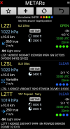
FLY is FUN is designed by pilots for pilots. FLY is FUN simplify flight preparation and improve situation awareness during flight, providing information on airspaces, reporting points, position on moving map, elevation, frequencies, railway, weather info … facilitate access to airfields related PDF document. Application also displays NOTAMs and data from rainfall radars.
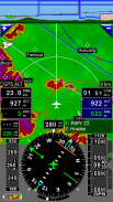
FLY is FUN simulates ILS approach, VOR, NDB, DME, Marker beacons, RNAV navigation and Marker beacons warnings, without ILS/VOR/NDB/RNAV equipment on board.
You can test FLY is FUN for free during few days. At the end of the trial period, pilot is invited to subscribe and pay an annual fees. Doing it, he get the right of using the application "as it is" and contribute to development effort.
FLY is FUN allows:
- Creating and modifying routes using "drag and drop", "rubber band"
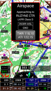
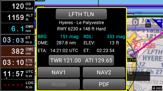
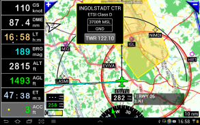
- Getting warnings, alarms and radio info before entering controlled or special use airspaces, approaching points
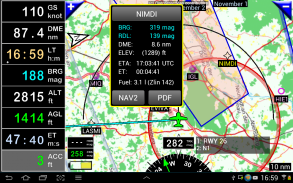
- Performing route planning, evaluating distance, time and fuel consumption (depending on wind and aircraft characteristics)
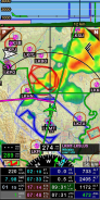
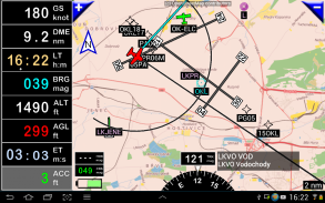
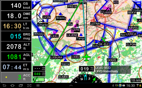
- Displaying route, bearing, trace on moving map
- Visualizing airspace
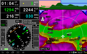
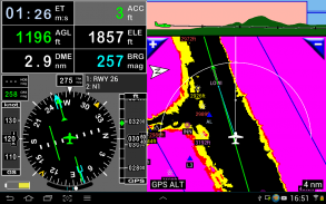
- Getting dynamic terrain map (colors depending of elevation above ground level)
- STRATUX support
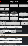
- Creating and exporting Flight Plan
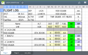
- Creating and exporting Flight log
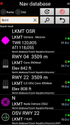
- Creating, importing or exporting routes, waypoints, RWY, airspace (Garmin .gpx, .kml, txt, OpenAir)
- Recording the flight and playing it back with Google Earth
- Sunset / Sunrise
- Getting weather forecast along the route
- Rainfall radar
- Wind displaying
- Calculating distance between 2 points on the map
- VACs
- Notepad
…
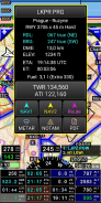
All main screens (5 portrait and 5 landscape could easily be customized. Pilot can choose from around 100 values to display. Example:
- Altitude GPS or barometric
- Ground speed
- Bearing
- Vertical speed
- DME to next point / destination
- Estimated time to next point / destination
- Time since departure
- Stop watch
…
Displayed information could be customized too depending of users preferences (VFR, IFR or both) and zoom level. The more you zoom IN, the more detail, information, waypoints,.. you see
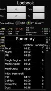
Logbook
The integrated logbook, allows recording:
- Duration since departure time
- Departure and arrival time
- Departure and arrival airport
- Flight track (it is possible to export it as .kml or .gpx and to replay it)
- Used aircraft
- Pilot(s) and copilots in charge
- Distance, average speed, maximum speed
…
Navigation data available from open source database are updated according AIRAC cycles.
Charts and elevation dta
Free charts and elevation data are available for most of countries and could be imported directly via the application store.
Other charts could be created and imported by the pilot itself or made on request available as commercial service.
Pilots could select the most appropriate charts: free open source charts as well as commercial charts as ICAO, Cartabossy, SkyVector, FAA sectional and terminal charts…
VACs and PDF files
VAC and AIP infos are available for more than 50 countries
User can easily attach your own PDF files.
Usage of external GPS connected via Bluetooth is possible
User guide: http://www.funair.cz/downloads/manuals/flyisfun.pdf
If you have any suggestion to improve this application or you find some bug please visit www.flyisfun.com
Use this application for VFR FLYING ONLY!!! We are not responsible for any use of this application.
FLY is FUN Aviation Navigation - Version 34.21
(26-03-2025)

FLY is FUN Aviation Navigation - APK Information
APK Version: 34.21Package: gps.ils.vor.glasscockpitLatest Version of FLY is FUN Aviation Navigation
Other versions


 3.79
3.79

Apps in the same category

You may also like...


